
In the footsteps of Dirk Hartog
Back, once again, at Quoin Bluff, we were studying the charts and the weather trying to see if we could explore the northern end of the island. One of the issues with Dirk Hartog Island is that once you leave Quoin Bluff South and head north along the east of the island, there are really no anchorages that provide any shelter for winds from the south, east and north. It is about 25nm from Quoin Bluff South to Cape Levillian, which is located on the north eastern tip of Dirk Hartog – so a long way to travel back to a safe anchorage if the weather gods decided to mix things up a little.
Whilst waiting for the weather to line up, we were able to get in a quick fishing mission to the south side of the bluff. We had previously done well here for snapper and today’s expedition was a little slower, but Nicky came home with the goods with a nice pink snapper. Dinner sorted!!
We love a good squid hunt and spent a few hours chasing these elusive critters – tricky to find in this area and whilst we had a few ‘followers’ we weren’t able to land any squid this time. Our track record for squid in Shark Bay has been pretty dismal…. certainly nowhere near the success we always seem to have at the Abrolhos Islands.
Monday morning arrived and,after checking the weather, we decided to pull anchor and head to Cape Inscription and Turtle Bay, located at the northern end of the island. Conditions weren’t going to be 100% ideal, but good enough and we were super keen as we hadn’t made it to this part of the island during last year’s travels. We had a light south easterly and headed north, the plan being to run close to the island so we could check things out.
You realise how big Dirk Hartog Island is as you slowly cruise down the coast with the island continuing to reach on into the distance. A lot of untouched beaches and unspoilt coastline here and, for the duration of our passage, we only saw two groups of campers and two other boats. Lots of places we wanted to stop and explore but again no great anchorages and we wanted to get to Turtle Bay to explore.
As we approached the north eastern tip of the island, Cape Levillian extends out to the east and a short distance off the coast lies Levillian Shoals, an area of reef that sits just below the surface. With a combination of tide, swell and wind in that area, discretion is required! We had planned to cut between the Cape and the shoal, however on approach could see waves standing up and we weren’t really too sure about it all. So, we did an abrupt 90 degree turn to the east and tracked out and around the outside of the shoals before turning back westward once we were clear of both the reef and the cape. Better to be conservative!

We now had a full view of the coast at Turtle Bay and onwards to Cape Inscription – which consists of some beach that runs up into high bluff style dunes and then into the corner of Turtle Bay where it turns into cliffs that stand about 100 metres high.
Coming in close, and in about 4 metres of water, we found a spot that looked ok for anchoring. We deliberately set the anchor so we would have our stern not too far off a small reef as we figured we could fish off the back of the boat at anchor. Certainly not a lot of protection here, but the weather was in our favour and we would just see how things panned out.


After tidying up the boat and waiting for about an hour, just to make sure we were secure in the anchorage, we took Bob into the shore with the intent to climb the dune and check the view. We had to dodge a bit of a shore break, but made it in without incident and pulled Bob up past the high-water mark. There is the remains of an old jetty at this location and the goat track we were about to climb used to have a small tramway next to it. Some of the original tracks, from the early 1900’s, are still located on the dune and this was where supplies were brought in for the lighthouse and then winched up the hill via the tramway. It would have been interesting seeing the transportation of goods in action, as this is one steep hill and climbing it almost involved crawling on hands and feet.
An awesome view from the top with Dorre Island visible to the north, the breakers on Dampier Reef indicating its location – about halfway to Dorre in Naturaliste Channel – and of course we could now get a glimpse of the top of the lighthouse. One of those spots you could just sit for hours and stare out to sea at all the goings-on. We even saw our first humpbacks for the season making their way into Shark Bay.


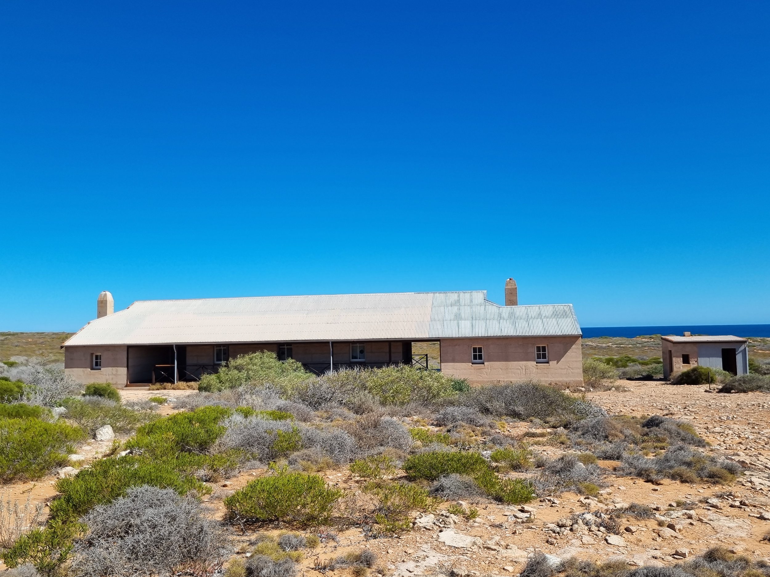
The next day we planned a walk to check out Cape Inscription – the lighthouse and of course Hartog’s plate. After climbing the dune at Turtle Bay, it was shoes on for about a three kilometre walk to the lighthouse. We were on one of the vehicle tracks that allow for access on DHI – not that you really see all that many vehicles. Soon we had a glimpse of the lighthouse keeper’s quarters and of course the lighthouse and soon we were walking into the Cape.
The lighthouse keeper’s quarters were in great condition having been restored fairly recently. All of the doors were unlocked and you could enter and check out the polished floor boards and fireplaces. It is now used to accommodate volunteers doing wildlife research, but I think is only used a handful of times a year. An amazing view out to the west from the verandah, and an awesome spot to sit and gaze out to the Indian Ocean.


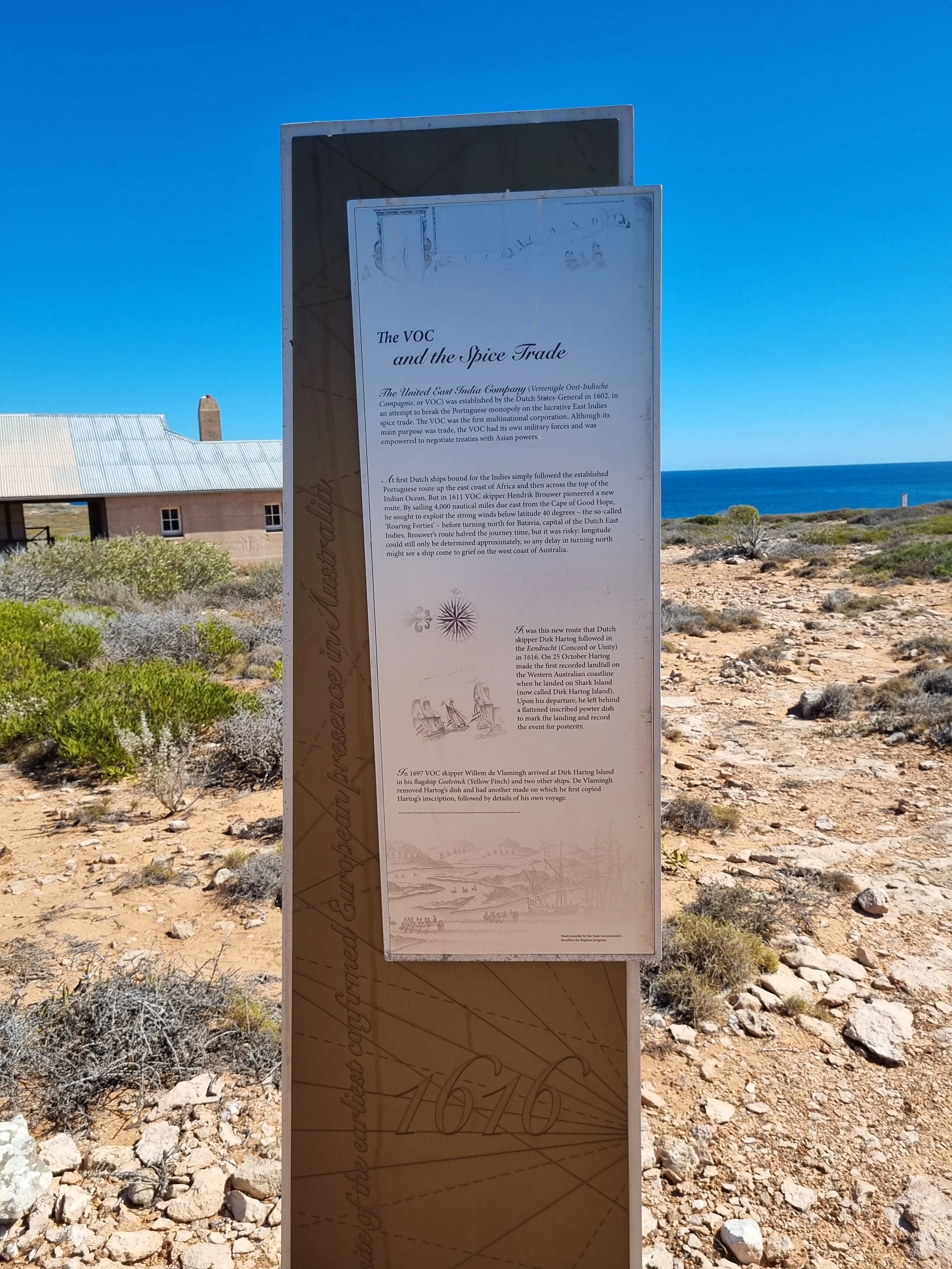
From the back of the quarters, it is a short walk up to the top of the cliff where the memorial stands to celebrate the location of Dirk Hartog’s plate. For us, it was really satisfying to be here, having read a lot of history of the West Australian coast and the various shipwrecks and sagas that took place hundreds of years ago. Also satisfying to realise that the view you were looking at was essentially the same as those mariners would have had 400 years ago which made it all that more special.


We spent a few hours poking around before walking to the west where we sat atop the cliff and had some snacks and a cuppa that we had brought along, then it was time for the return walk back to Turtle Bay.
That afternoon, it was lines in and soon we had a couple of nice big spangled emperors for our trouble. Best was 63 centimetres and we were pretty stoked to be catching them straight off the back of the boat. Needless to say, it was snapper for dinner that night – happy days!!


Looking at the weather forecast, we would have to leave on Thursday to avoid some stiff easterlies that were coming, so Wednesday was the day to get wet and do some exploring in Bob. There was a surf break around the point and about 3 miles south and we contemplated heading around there, however our risk assessment came into play and we decided against it. Whilst there were a few boats around, if we had an engine issue or some other mishap whilst on the western side of the island there is nowhere to come ashore and you would find yourself at the mercy of the exposed reef and cliff. Something we didn’t want to chance on our own, so, unfortunately, no surf exploration for us.
The next day we did some exploring in Bob and then had a couple of great dives along the northern side of the Cape. The water was noticeably warmer than in Shark Bay, being exposed to the northern currents and thus the fish life was abundant and we saw a great variety of fish, including a few species we hadn’t seen before. We changed locations a few times and found some big aggregations of fish, particularly baldchin, emperors and tuskies. To highlight the variety, we saw two different sea snakes in the one location – something we haven’t seen before.
Soon, light was fading and we were getting chilly, so back to the boat to tidy up and prep for passage to Cape Peron in the morning. Whilst we had the anchorage to ourselves during the days, at night we were joined by a few boats, including a charter boat (Top Gun II) and two or three small recreational boats who’d anchor up after a big day out fishing on the water.
We had really enjoyed our time here and vowed to return on our way back south this year, as it is such a magic spot. Hopefully, we can time our visit with the prevailing southerlies so that we can see it at its absolute best!
Next stop Cape Peron, the northern most peninsula of Shark Bay.